Spain is right below France and borders Portugal as well. It is in Southwestern Europe the exact coordinates is 40 00 N, 4 00 W
The terrain is a large flat plateau surrounded by rugged hills.
The average altitude is 660 meters which is 2,165.35 feet. The highest point is Pico de Teide on the Canary Islands and is 3,718 meters which is 12,198.163 feet.
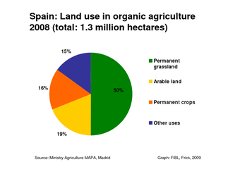
54.1% is used for agriculture, 36.8% is consumed by the forest, and 9.1% is used for other.
The current environmental concerns are the pollution from the Mediterranean Sea that is caused by raw sewage and the offshore production of oil and gas.
The climate is hot summers and cold winters in the middle of Spain.
Madrid, Spain’s capital, is in the center of Spain. It’s coordinates are 59 56’58” N, 10 45’23” E.
Madrid is 2,000 meters above sea level.
It’s climate is cold winters with some snowflakes and hot summers that can reach up to 104 degrees